Solutions for Managing Critical Infrastructure
Dennis Beck, President/CEO, SBS
Introduction
This summer (July 2021) I had the good fortune of being able to deliver a Spotlight presentation for the Esri User Conference. My goal of the presentation was to take some of the hype out of digital twins (Trust me, there is a lot of hype.) and also to introduce the important concept of the digital thread, which is often overlooked in our critical infrastructure community. The presentation was well-received, and it was referenced in the VentureBeat (www.venturebeat.com) online publication. This blogpost summarizes the presentation and provides some additional details based on questions we have received here at SBS.
What is a Digital Twin?
In its simplest form, the digital twin is a digital model of a real-world object. Each twin represents a unique occurrence somewhere in the real world with the necessary sophistication to support relationships between objects and other elements within the system, including dynamic, sensor-based information. By its very definition, the digital twin is a non-static representation. It can grow over time, becoming more and more data rich based on construction information, asset history, and sensor-based data inputs. It can be thought of as a data container that becomes filled with more and more valuable information over its lifecycle. It is like a lean gymnast who grows into a sumo wrestler.
While digital twins have been getting a lot of hype over the last many years, it’s important to realize that the critical infrastructure GIS community has already been creating some form of digital twins for many years. They were initially known as “simple features,” but the technology has advanced to incorporate network modeling, federated data sources, sensor-based data (including Lidar),and advanced, geo-enabled applications. What was originally a very simple modeling construct has become a quite sophisticated, mature ability to model real-world assets.
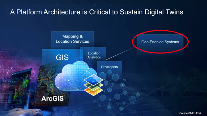
In working with digital twins, it is critical to have the ability to rely on information from many different systems and to have an architectural platform that ties all this information together. GIS is consistently recognized as that platform. In particular, the ArcGIS platform is very rich in its ability to manage and integrate with other geo-enabled systems, supporting these applications with 2D and 3D representations, spatial and non-spatial relationships, network modeling, and many other powerful modeling constructs.
How About the Digital Thread?
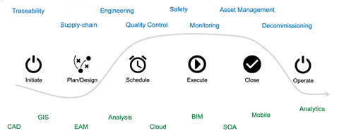
Now that we’ve defined the digital twin, let’s discuss the concept of the digital thread. Infrastructure design, build, and operation tends to follow a certain pattern: Initiate, Plan and Design, Schedule, Execute, Close, and Operate. Throughout this pattern, there are a number of business processes that typically happen throughout an asset’s life cycle. Here are some examples:
- Material traceability
- Engineering
- Supply chain
- Management and maintainability
- Decommissioning
- And more
That means an asset touches many different systems (CAD, GIS, engineering analysis tools, etc.), and that list of systems is not getting any smaller. The path that the asset or digital twin travels through these systems is what we refer to as the digital thread, which can begin at or before the inception of the asset all the way through its operation and decommissioning.
Challenges to Implementing Digital Twins and the Digital Thread
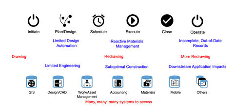
The digital thread and its associated digital twin have the potential to generate a tremendous amount of value in the design, construction, and operation of critical infrastructure, but historically, there have been a lot of challenges that have prevented us from implementing this vision. Here are some of the key issues:
- There are a significant number of systems that need to be accessed, which adds extensive complexity to a properly implemented digital system. This is manifested in different ways, but one challenge we’ve seen over the years and decades is extensive data re-entry.
- Looking more specifically at graphical information, organizations will design something initially in a CAD system and then they will then redraw it in a GIS to create a system of record. The redrawing doesn’t end there as a different graphic representation of the data may be required to support specialty applications such as network management systems. This extensive re-entry of complex, graphical information results in complex data duplication issues.
- The actual engineering of the planned infrastructure systems tends to get short-changed due to the complexity of moving data between the designs and the specialized engineering tools necessary to perform a detailed engineering analysis. This creates suboptimal designs.
- This limited automation and lack of detailed information can impact the material accuracy. As a result, the supply chain and materials management become reactive as opposed to proactive, which then impacts the success of the field construction. This is where it can get very costly for infrastructure owners and operators.
- No matter how well you digitize all your designs and information going out to the field, if it’s printed out and put in a folder, that creates a big information gap with out of date records during construction and as-built documentation.
- Ultimately, the casualties of this bad information flow tend to be those downstream applications that rely on very current information to perform advanced business functions that should be taking advantage of robust digital twins.
How to Overcome the Challenges
There are many things that can be done to make your digital twin and your digital thread implementations a reality in spite of the challenges identified above.
The first step is to think architecturally as you implement your information systems, keeping your end goals in mind.
- Use an intelligent design system. Since the design process is where the asset information is created, it is important to use an intelligent design system to create the well-defined objects that form the digital twins. Some organizations take shortcuts during the design process via the use of simple drawings or even just sketches. Instead, a well-conceived approach to building intelligent models will enable geo-location, materials management, network topology, and the other elements necessary to build, operate, and maintain critical infrastructure.
- Be spatially aware throughout the entire process. All critical infrastructure is dependent on location, and this has a significant impact throughout the asset lifecycle from construction through operations and decommissioning. Proper spatial enablement opens opportunities to incorporate less-commonly used datasets for soils, weather, vegetation, and other emerging sources of data that can be used to make advanced asset management decisions.
- Don’t lose track of the data. A properly architected system will be structured in such a manner that data is not only retained but made available in a usable form to support lifecycle business applications, many of which have not yet been identified.
- Keep security front and center. As we architect systems to make the data more and more available for advanced applications, we also have to realize that it has the potential to create vulnerabilities that can be exploited by bad actors.
The second step is to address the fact that there are many different personas that will be relying on the digital twins. Consider an electric pole: a designer needs to have detailed information about attachment heights, connections, angles, and more to determine the proper structural characteristics. A manufacturer needs the base material information, specifications, and usage conditions. A builder needs to know not only the detailed plans but also the detailed real-world location. That real-world location is not nearly as critical for the maintainer; instead, the maintainer needs to know how to access the asset and how to not violate any right of way concerns or environmental restrictions. Furthermore, the operator may not care where the pole is but must see the operational picture of the network environment. Finally, the asset manager needs to understand the financial profile, the reliability history, and all those events that contribute to aging and key decisions in optimizing the asset life cycle. Each of these different personas has unique needs that must be thoroughly considered.
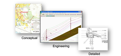
The final step is to focus on the necessary data transformation to make information usable to different consumers. This is an area where SBS has been doing extensive work to support the business requirements of the different digital twin consumers and representations. The example below shows electric transmission system assets from conceptual to engineering to detailed design. All three representations reference the same system, but it has to be transformed for the different consumers.
Current Examples
This section shows some examples of our efforts at SBS in using digital twins and digital threads to solve infrastructure management challenges. We refer you to our Esri User Conference Spotlight presentation for more details. In the presentation, you will see the following:
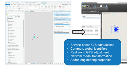
Design integration with CAD and GIS
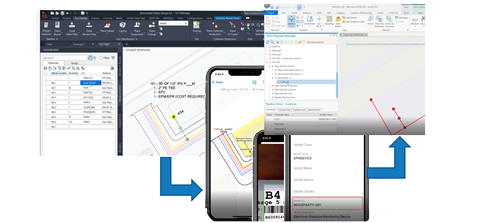
As-built integration with CAD, mobile computing, and GIS
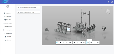
Integration of 3D intelligent design models with operational digital twins in an electric substation
Conclusion
Digital twins are a very powerful construct, but to take advantage of them requires a change in how we think about managing infrastructure information. Part of that thinking needs to flow into the digital thread, which expands the digital twins to be part of an integrated asset life cycle.
A well-conceived, geo-enabled architecture generates very significant benefits. The design process becomes much more efficient when using intelligent models to build twins. Data re-entry is reduced quite extensively, which can provide more current information to support advanced applications. This opens the door to other exciting things such as optimization of asset performance and the ability to generate analyses that we haven’t been able to do before.
If you have any questions, please contact SBS at info@spatialbiz.com. We are happy to help you with your digital twin and design integration requirements for critical, networked infrastructure.

